All posts by Frank Widmer

Coromandel

My summer season in Doubtful Sound has finished in late May, just the right time before it get cold and snowy. This time I decided to move on to warmer locations in New Zealand direction; not exactly known wherever the road takes me.  Shortly after my seasonal contract finished I started my trip to North of New Zealand, passed scenery and city’s where I have been before and old memories came alive. From Picton I had to take the ferry to Wellington, from there I rode straight to Coromandel Peninsula where I stayed for nearly two  weeks, it is already late May and off season, this is the time time of the year when it is not very busy, all accommodation is much cheaper than in the summer month. Mostly I stayed in BBH Hostels on my trip, never had a bad experience, my bike was always in a secure location  parked overnight or even locked up in the yard by the hostel. I did some camping too, however nights got very chilly already and in the morning was some condensation on the  inside of my  tent, as soon the sun came out the tent dried up very quickly mostly late morning I took off to my next destination.

Coromandel Town is a good starting point to ride to Port Jackson, on the way I stopped one more time at Colville for one more night camping at Colville Bay Motel it is a unique place to stay, it is very basic for camping but everything is around what you need, the owner are very friendly and welcoming. Next day I started a bit earlier than normal, to ride to Port Jackson it is a unsealed road in a very good condition, more to look out are the local driver they are speeding up and down the road. At Port Jackson is a DOC campground with a Ranger who take care and look after the area. After this visit I went to Port Charles, it is a very rural location, but mobile reception is available, and it is very good for fishing from the wharf, it didn’t took us a very long time after we cast, we caught a big snapper big enough to feed a whole family. The way back to Coromandel was as exiting as the rode I rode before. The hills are very steep and overgrown with trees and ferns after each heavy rain shower or pour down many landslides occur beside the road, I passed landslides they where big enough to cover the whole road from one side to the other, but road worker where as soon at work, as the rain stopped and it was safe to dig out the road from mud and trees. In Coromandel I stayed for a few more nights to relax.


Piano Flat and Waikaia Bush Road

I was planning this trip for some time, the preparation was done but the weather was not suitable, the track is very challenging with many unexpected obstacles. The Waikaia Bush road or Whitecoomb road goes from Fruitlands to Waikaia through private farmland and later through DOC land. The road is much easier if you start by Fruitlands and continue to Waikaia. We took Waikaia Bush Road the access is just around the corner by Shingle Creek coming from direction Fruitlands.

On the first 8 km are few farm gates to open the road is in a very good maintained condition. After the last gate DOC land begins and the road is not maintenance, the road is filled up with rain water which could be front wheel deep or only few inches, but the mud in the paddle is very soft bike is drifting from one side to the other, most difficulty is the tyre marks from 4WD cars which can’t be seen at all, then relay to your luck to get through. I cannot recommend to try riding around the paddle, the ground is very soft as well and the tussock very thick. I drove through all paddle it was very slippery. After I managed the last paddle the road got rockier with wash outs, I decided to drive in the washouts which are not very deep, but without any mud, the tyre had a reasonable grip too. On the next section I experienced a lot of rock steps which remained me more riding down a staircase than anything else. The steps were as high as 40 cm and super slippery covered with a very thin layer of mud and gravel. It is possible to camp beside the track and the scenery is very beautiful, there is a swamp on top of the range too. After the 4WD club stuck in May 2016 the last part of the road (on the Waikaia site) has been improved a lot, there are no wash outs or gaps in the road. It is extreme slippery in wet condition. I put on a brand new Heidenau Scout 60 tyre I have had to work very hard to keep my bike on track.


macquarie island

Macquarie Island is one of the Subarctic Island, which is located in the Southern Ocean, just half way between New Zealand and Antarctica. Macca is the nickname of Macquarie Island and is a nature Reserve managed by the Tasman Parks and Wildlife Service. The Island and surrounding waters are protected in a radius of 12 nautical miles. The geoconversation is significant. The land under water, and all fauna and flora including fish and marine plants are fully protected.

Frederick Hasselbough discovered the island accidently on 11 July 1810. As he was looking for new sealing grounds, the island was uninhabited, and claimed the Island for Briton. Hasselborough reported a wreck of ancient design, which has given the speculation that Polynesian or others have visited the island before.

The Island is about 34 km long and 5km wide, with an area of 128 km sq. Near Macquarie Island are two smaller islands. The islands highest point is MT Elder on the northeast ridge 385 m, and Mt Hamilton and Fletcher in the South at 410m.

Macquarie Island is rich on wildlife include subarctic fur seals, Antarctic fur seals, New Zealand fur seals, and southern elephant seals, more than 60 000 individuals are known. Royal penguins, Macquarie Shags, king penguins, southern rock hopper penguins and gentaoo penguins breed in large numbers on the island. Since 1948 the Australian Antarctic Division has maintained a permanent base, the Macquarie Island Station, on the northern end of the island at the foot at Wireless Hill. The population of the base varies from 20 to 40 people over the year.

Tourism has a very small impact on the Island, not more than 250 to 400 visitors are visiting the Island over the year. The only access is via cruise ships which usually traveling during the summer month into the subarctic to visit Subarctic Islands.

Macquarie island is the last Island before Antarctica, it could get very rough at sea from time to time, and a landing is sometimes not possible due the high swell at the beach side.


Akaroa Island

Akaroa Island is just around the corner by Christchurch, there are a costal drive and the much longer drive on the main highway. I took both roads first I passed Lyttlton to Governors Bay continued to Diamond Harbour. The road is sealed until Monolau from that village on the road get unsealed with deep gravel was not easy to ride with a heavy bike, the further I got into hill side the more the road looked like a 4 wd road, unseals slippery and full of pot-holes. The whole scenery is very beautiful and changes many times, all the time a look out offers a great view to the costal area. The road gets connected to Little River. I took a sharp left turn on SH 75 and drove to Onawe Pa, it is historic place to stop singed in 1832. Nowadays it is a Hotel and Restaurant with a view to Barry’s Valley and Barry’s Bay. There is only one road to Akaroa. Akaroa it self has a strong French influence from the past. Many street names are in French, to police station get called Gendarmerie too. At the far end of the road is a Hostel located a good place to relax, in middle of the forest and mountains, far away from the township. Akaroa is famous for fresh fish, French style baked goods and salmon farming.

After my visit to Akaroa I drove to French farm a small settlement at French Farm Bay it is well signposted on the main road and a good opportunity to go for swim water is crystal clear. From there on I followed the road up into the mountain, a typical 4wd road what I found out. The luck with the weather was not on my side, far up in the mountain clouds moved in very fast and the wind picked up my visibility was not more than 10 meters. That contrition continued the whole road up to Mount Bossu, there was a sharp right bent. The weather changed completely, clear blue sky and sunshine was my reward, and I can say that much it was worth it to keep on going. Landscape got better and better, it was time for afternoon tea too. To sit in the field to relax was awesome no notice was around just plain nature. Following Bossu Road to Reynolds Valley is an easy ride, the road is following the ridgeline, and soon the road is going to Kinloch and Breitmeyers. It took only few more meters to go until back on the SH74.

The colonization started in early 1800 at Akaroa Island, it was the same time were the French established in the Pacific region. Approximately 50 to 60 whaling ships were sailing between New Zealand and France. The Wale trace was very lucrative that time; Oil lit street lamps in Paris and other big city’s all over Europe.

However just one month before the Comet de Paris left France, the British signed the treaty of Waitangi with the Maori Chief, at the bay of islands, on the 6th February in 1840. Just 1 month later the Southland Chief of Maori signed the treaty, on 30th May the same year.

The unknowing French arrived at Akaroa Island in August 1840 and discovered they would be settling into a British colony. After the signing of the treaty, a British warship had sailed to Akaroa and planted the union jack. The land had been bought by Langlois had been sold again, as it was often Maori Custom. The British Settler stayed calm, due to much diplomacy that time, no major incidents has arise that time. The French Government requested the British Government to protect the rights of the French landowners in New Zealand, and that was agreed upon in 1841.

Langlois returned to France in October 1842, with a cargo of more than 1.700 barrels of whale oil.

The French settled as planed in Akaroa, but instate a large French colony, just 2 towns had been build with around 60 French inhabitants.


Champbell Island

Champbell Island is an other Subarctic Island that belong to New Zealand. It covers 112.68 square kilometer and is uninhabited. The Island is mountainous and raising up over 500m to the South. Champbell Island is a UNESCO World Heritage Site.

The Island was discovered by Captain Frederick Hasselborough. The Island became a seal hunting place, and the seal population was nearly completely eradicated, the first sealing boom was over in mid 1815s, and the second was a short hunt in the 1820s. After the sealing boom, started the whaling boom in 1830s and 40s. Much of the topography is named after people which have been connected in any aspect in the late 1800s

Sheep farming was undertaking in 1896, and a small heard of cattle was abandoned in 1931 of the great depression.

During WW2 a constant watching station was build at Trucker Cove at the north shore. After the war the station was used as a meteorological station until 1958. When New Zealand build a new one at Beeman Cove.

The climate at Champbell Island is maritime. The Island receives only 647 h of sun shine annually, and has a annual rainfall of 1.329 mm.

Marine mammals have shown good recovery after all pests have been eradicated. Sea lions and southern elephant seals have begun to re-colonize the island.in the winter month some southern right wales visiting North west Bay and Presverance Harbour. Yellow Eyed Penguins living in the island as well.

The Snares

Snares Island also known as the Snares, is a small island 200km south of Invercargill, the snares have a land area of 3.5km Square. The island has been first sighted by European on 23 November 1791 by the Captain George Vancouver and LieutenantWilliam R. Broughton, both of the Vancouver Expedition, and called the island as the Snares they believed that the island is a shipping hazard. Unless other sub arctic islands that where affected by whaling and sealing in the late 19th the Snares remain one of the pristine islands of New Zealand.

The Island is uninhibited. The Island has the privilege that is highly protected, and get monitored by DOC. Visitors are not allowed to visit, from time to time research monitor the impact of the wild life, special permit must be asked for.

The Snares are home to the Snares Penguin, Seal Lion and Buller Albatross.

All the Snares Islands are bordered by high cliffs expect to few eastern parts. Climate is mostly influenced by weather constellation, which moving in from Australia or Arctic, weather can change rapidity.

The Snares are part of the New Zealand sub arctic Islands and are protected by UNESCO and have a world heritage status.

the branches road and station

Near Skippers Canyon by Queenstown is an other beautiful remote 4wd road called The Branches Road. Historically Skippers Canyon was the main area for gold mining in the late 1880, At first was Skippers Canyon Road build and few years later begun the building of The Branches Road. I rode both roads many times and both roads are a great adventure all the time, special on a Adventure bike. Before you reach turn off to Branches Road you have to ride Skippers Road which is at some sections a very scary road, the road follow few hundred meter above Skippers Canyon River, there is even not even enough space for two cars to pass each other, I need to watch out all times for dust clouds which where man made by buses or 4wd trucks, that I could look for a safe passing area to pull in. After I reached the rock fall area there is the turn off to the Branches Road to the right into the forest. The road is very exposed, sandy and rocky; what make to ride my bike much more difficult. As soon I reached the first hard right turn I saw a statue which is overlooking Skippers Town and upper skippers canyon, it was said that the statute is looking for the luck and safety for the gold digger.

From that point on the road get more spectacular than Skippers Road before. The road is more exposed and the cliff is getting higher than on the first part on Skippers Road. The excitement get more and more the further I rode down the road, I passed many fords which where not to difficult to pass, due the luck of rain, one of the Fords was just wheel deep but very big rocks where in the drive way a steep sand ramp was to drive up straight after the ford, my bike begun to swing from right to left, but I got my bike back under control with out coming off it.

Further down the valley I found a green area in middle of an forest which I juice to camp for the night, as a farmer told me it must be the historic supply house on right side of the river, it is the only access to the left side of the river by using a flying fox too, the flying fox is in top condition and get used nowadays. We started pitching up our tents and light up a bone fire. But as soon the day light faded away, little blood sucking animals which we call sand-fly’s make our pleasant first stay very unpleasant. But any way; we didn’t break down our campsite and enjoyed our BBQ and our night. In Early morning hours some animals where running around my tent I have had no idea what kind of animals that could be, after one of them attacked my tent I went outside and checked out the situation. Surprisingly there was no danger at all, there where many rabbits playing and running all over the green, one of them must slip and roll over and bounce back from my tent. It was a great experience to sit on the side and look at the rabbits, what a great start into the day, it was so peace full, around us.

After Breakfast we continued our adventure ride to Branches Station, one section was more challenging, rocks as big as footballs; drifting sand in between them make the passing more difficult. That part is only passable by low water of the river, on a bike. That is the only part of the whole road which can make the ride an obstacle. After our success full passing it was easy going until Branches Station. Many confusing notes where at the entrance to the station. We dried to find the farmer to get permission to go further up the private road, the farmer was so kind to give us permission to continue our ride, he recommended to take the steep gravel road up to the top of the hill. From there we would get the best panorama view over the whole valley. Once more a steep climb smaller and tighter serpentines than ever before, may more suitable for a small 4wd car than for a full loaded adventure bike, we went that far already and no one of us want turn back with out that promised view, it must be a gradient of 45 degree, tough, no way back… keep going and don’t look back down.

The view was incredible, stunning, mind blowing and overwhelming. The only big disappointment was I didn’t ask for permission to camp at this location. We took the same way out of the valley as we took in, every ting seems to be easier than before, but wasn’t. We stopped at the original Skippers Home State to take a close look of the well maintaineced cottage, historic tools where hanging outside and where displayed inside as well, an old iron bed was on the far end of the room the fire place was nicely set up with pans and kettle.

May Queenstown is called Adrenalin capitol of New Zealand, definitely Skippers Canyon and Branches Road is Adrenalin capitol of Queenstown.

There is one more good rule on those roads, the road is not suitable for camper vans at all, and if some one rent a car, this is one of New Zealand roads which the rental company exclude any insurance. In the whole valley is no cell phone coverage, if a break down happen it make it very difficult to find fast help by phone, more likely it is a long walk back to the entrance of the road to make the needed call. Even than it is not certain some one pick you up due the difficulty and danger of the road.


The Branches Station is a high country farm with 90 000ha of farmland, Sheep and cattle are the most livestock which is on the farm

There is a chance to stay at the branches by one of the farm houses , which is called Stockman’s Camp, to experience that unique and pure, untouched environment cost its price.


Yangshuo; Kunming; and Haikou

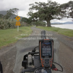
For the last 1.5 years I was planning a motorbike tour to Asia. I looked into a transport option from Auckland to Kuala Lumpur for my BMW Sertao bike. My flight was booked from Auckland to Kuala Lumpur. Early March. If I would be able to do my original plan I would ride my bike after I finished my summer season with Real Journeys to Auckland. At the end I had to change my plan due problems which could not be solved by BMW in New Zealand. Since I have bought the bike I experience problems with stalling. After many service arrangements in Christchurch, Dunedin, and Queenstown I decided not going on the bike on holiday.

I started make last minute changes and booked a flight from Queenstown to Auckland, and continued with my first booked flight to Kuala Lumpur. As soon I passed the customs I looked for a transport option to Kl, there are 2 Taxi operators one of them is a metered Taxi and charge peer Taxi meter; the other one is a fixed price, I juice fixed price option and paid 71 Ringgit to my accommodation. Be aware if your flight leave early in the morning the Taxi charge a surcharge of 50% of regular price between midnight and 6.00 am, the ride from my Hotel to airport cost me 150 Ringgit at the end.

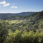
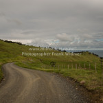
Check in by Air Asia was easy, my flight to Guilin was on time. Guillin experienced a very heavy rainfall over last 2 days, and the humidity was very high. The immigration officer didn’t ask any question about my visit, checked my visas and return ticket that was everything, entering China was very easy. English is not widely spoken in public places. Before I left Malaysia I took a screen shoot of the Hotel name and saved it on my I-phone. It took some negotiation about the fee from Guilin Airport to Rosewood Hotel in Yangshou, Taxi driver want RMB 500 for the transport, what was to much, at the end I paid RMB 400, which seems still very expensive. We used the highway passed many small villages to the right and to the left, all of them where imbedded in between beautiful mountainous landscapes with rice fields and farmland around. Due the heavy rain the highway was covered in water sometimes it seemed like a river, the car was sometimes unstable on the road. After we used the highway the Taxi driver took a side road, which was not sealed, had many potholes and more water on the surface. At this time I have had no idea what direction the taxi was taking, houses got less and less. After 40 more minutes we reached Yangzhou. The rain was still pouring down and I showed the Taxi driver the Hotels address once more, he stopped beside a Hotel which didn’t look like Rosewood Hotel at all, my driver took a second look and rove down the road to an other Hotel which didn’t look Rosewood again, he “called” the Hotel and reversed the Taxi, than stopped in the same road, hotel here, took my bag out of the boot of the taxi and the taxi dissapierd. I was happy that I reached the hotel. As I checked in, no one spoke English oops I thought something is wrong. However we called the Hotel I have booked, the direction I had to take was very easy go to the petrol station opposite the hotel and turn right go to the next round about and turn left, by the bridge turn right again. I started walking in the warm summer rain up the road, kept walking and walking, endless long roads, in the pouring rain. Last time I have been soaked that much it was in Milford Sound the only difference this time was that I have been asked every few meter if I need an umbrella, if I would have one it wouldn’t make a difference, by now, because I have been drenched already. But I couldn’t find the 2nd bridge, where I have turn right, as wet I was I went into a Hotel I passed and asked the receptionist, usually in every Hotel, Bank or Post office is one person who is speaking English, not to worry if you get lost, we called my Hotel once more, one of the office staff had to walk from Rosewood Hotel to the Hotel I was stranded, to pick me up. I couldn’t believe I have been so close to Rosewood Hotel already; it took us only 3 minutes walking.

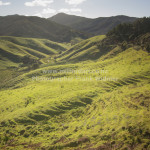
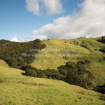
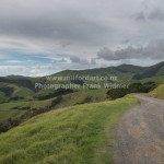
I received a very warm welcome in the Hotel, with one glass of warm water and a towel. The Hotel is on the main street, at night time all social live is around, bars restaurant KTV are just beside, West Street is absolute boozing full of party hungry people, party time is until early morning. In many bars is live music, and karaoke. In the early morning hours is not much happen, break fast is taken in one of the restaurants, it doesn’t take long until first Tour Guides get in contact and dry to sell tours on a Tuk Tuk, motorbike, or bicycle. Few of guides where approaching me, at the end I booked a motorbike tour with Peter a local from Yangshuo. Following morning he picked me up in the Hotel, after a short walk we picked up our motorbikes. And left City and went into the country side, we passed many rice fields and went further down to the Li River, stopped by one of the old villages, after a short break we took off, the further we went the better it got, one other highlight was to stop at a melon plantation, one of the farmer came along with fresh harvested melons, without pealing skin off I took a big bite into the melon, the sweetness was awesome, even today I can remember the taste of it. Thanks my guide we took many beaten tracks through the farmland, many rice fields, and more plantations. Out of nowhere came a big black snake moving over the path. Now we where in snake territory!!! We continued out tour and had one more stop by moon rock. The whole tour took us at the end 6h. But 6 hours is not enough time to see all the fascinating country, I found out that would be a nice place to stay for a while, my time was limited this time. After I went back to my accommodation I got changed and get ready for nightlife, nightlife does not disappoint at all in Yangshuo. In general it is not easy to find a chines cooking class Omeida Academy offers different classes in cooking, I booked a 3 day intense cooking class. Classroom where located in an old farm house in the country side around 15 mins drive out of Yangshuo.

This time I took the public bus from Yangshuo to Guilin International Airport, to get my flight to Kunming in Yunnan Province. My taxi was waiting already in Kunming it took me 1.5h to get to my accommodation. I found a very cozy Hostel with very good references on Trip Advisor. It is called Lost Garden Guesthouse all staff is fluent in English and dressed in traditional costumes. The check in, was very relaxed and took its time. The rooms are very comfortable, and very quiet at nighttime. To my surprise the menu is very European, fancy salads, different kind of Pizzas, and pasta was on offer, at first I was suspicious about the food option, but I Joyce to eat in today and ordered a vegetarian pizza, pizza dough was home made a perfect cooked tomato sauce and a topping which best ingredients. There was no difference to an Italian Restaurant in Italy from taste flavor and presentation; the only difference to Europe was that no European chef was in the kitchen. I rate the food the most authentic Italian food outside Italy. Yuantong Temple is a 10 mins walk away from the Guesthouse and dated back more than 1200 years grandest and most important Buddhist Temple in Yunnan province, the temple closes at 5.00 pm. Next street down to the Temple is Kunming Zoo located. Dynamic Yunnan is an international awarded winning musical. Bird and flower market is on old street and is open until late, very good for souvenirs to buy.

Kunming is nearly 2000m above sea level, in summer month temperatures are moderate, not to hot.

After I visited Kunming for a week, there was still a week left before my departure back to Kuala Lumpur. For the whole holiday I have had a gut feeling that I need go back to Haikou for a visit, and to catch up with my friends. Usually air tickets are very expensive from any airport in China to Haikou. The only day I was able to fly to Haikou and back to Kunming was on sale, 70% off the regular price. I finalized my booking. One day before departure I received a message from my friend that Hainan got hit by a typhoon and the airport was closed for the whole day. My thought, went crazy, not again a cancelation of my flight, because I canceled my visit already for 2 times. The day my flight was booked I took a taxi to the Airport, at first there was a delay on the departure board. After some time passed by the delay changed to go to boarding gate.

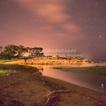
I booked the same Hotel where I did stay 2 years ago. Nothing has changed, at Sheraton Haikou Resort Check in was fast, my room had sea view this time. A very welcoming place is always the sea breeze bar.

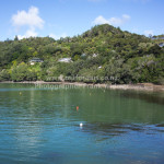
Haikou is one of the most beautiful city’s of china, with a no air pollution; its living cost is even very affordable.


doubtful sound

It was one of those late summer days in early 1950 when Mr. and Mrs. Hutchins went out for a weekend hike into Doubtful Sound, it was a 4 day hike return and full of challenges; a boat from Te Anau must be organized to get to the West Arm; from there was a track going beside the river and through thick bush-land over the Wilmot Pass which is 980m above sea level.  From there it took one more day of hiking until Deep Cove where there was a single hut to stay overnight with no comfort. But Mr. and Mrs. were so overwhelmed with the area and the beauty of the location that they bought a boat to show tourists around the area.   It took 4 days to get the first visitors from Te Anau into Doubtful Sound and that was the start of Fiordland Travel which got re branded to Real Journeys as we know today. It was tough making a living at this time with not many customers and tourists around. Still the founder believed in his dream to show foreigners the most beautiful parts of Fiordland. After a few years running the new business a second boat was bought, which was not very reliable and broke down many times. It was sold off after a short time, and a more modern boat was bought in Te Anau, business was going up and down. It was early 1970and the couple were involved in the Save Manapouri campaign to stop the government from raising the lake levels to help generate cheap electricity. More than 260 000 signatures were collected. No dam was built, but the power station still went ahead, which brought workers to Te Anau and they needed to get transport over the lake. That was the first big change in the company’s history.

Nowadays Real Journeys organizes daily cruises into Doubtful Sound. The Patea is the boat which runs day cruises, and Navigator runs overnight cruises. Both are modern standard with all facilities.


The overnight cruise is different to the overnight cruise in Milford Sound on the Mariner but both cruises are special in their own right. Doubtful Sound is ten times larger than Milford Sound; the mountains are not as steep and greener. Usually after boarding all customers get a fresh baked muffin and hot drinks which are complementary for the whole cruise. A short time after the boat leaves Deep Cove you can experience a silence and peaceful atmosphere under which all stress seems to be forgotten and left behind. Very soon the excitement gets bigger about daily water activity, there are 2 options to choose from; one of them is to jump on a tender craft to explore the fiord along the remote shore line; the second option is a kayak paddle on the fiord. Both options leave memories behind which won’t be forgotten for many years after the trip. I forgot the 3rd option – sorry about that – it is jumping from the boat into the Fiord and doing a good healthy swim in the clearest and pristine waters.   Yes we do that activity in late summer and autumn too the only difference would be the water temperature in summer is around 16C and in Winter around 12C – all the time refreshing. Shortly after the last activity of the day the soup service starts, from then on you travel to a seal colony, which is located just before the Tasman Sea. Sometimes you can see whales hanging around that area, but that is a very rare occasion.

The boat stays around this location for a while to see the awesome view back into the fiord.  As soon the boat is back to the fiord the dinner service starts. Everyone is looked after with all food requirements, Vegan, gluten free, lactose or Jain are only a few to mention.

As soon dinner is served, there’s a presentation about the history of the area in the saloon, with is very informative to listen and look at.

Next morning a cooked breakfast served. On the way into the fiord is for many customers a once in a life time experience: we call it the bay of silence, the boat shut down everything, fans, engine, radio’s. Everyone can experience how quiet and how the isolation sounds like without any pollution of noise, surprisingly a camera can ruin the whole experience with its peep- it is that quiet.

Soon after that experience we are back to Deep Cove, the harbour we left the day before.


The buses are waiting already for all passengers to drive them back to the wharf at West Arm in a comfortable air-conditioned coach. From there it is a 45 to 50 minutes boat ride back to Manapouri.


It has changed a lot since the first visitors started travelling to Doubtful Sound and it took them more than 4 days hiking with little comfort in the early days.


Auckland Island

Auckland Island is the biggest subarctic island, which belong to New Zealand, and is 465 km southeast from Bluff peninsula. With a combined area of 625sq km, the Island is uninhabited by humans, there is a wide variation of wild life all over the island, yellow eyed penguins, albatross, elephant seals and the nearly extinguished snipe enjoy the idyllic isolation on the island.

On the Island are 2 hikes, both of them start close to the landing site by research station, from there on; for the first few meter you need to pass sea lion colony, usually the seal are very relaxed and sleep. One of the walk is a 3 hour return broad-walk very easy to do, which winds up to a higher altitude, you pass wetlands, small forest and rata trees. Yellow eyed penguin’s nest very close to the broad-walk, and are not shy by passing tourists as long they keep a safety distance of a few meter. All the way long the scenery change, to take a look back to the harbour is magnificent. At the far end is a small rest area, which invite you for a while to stay and have a snack. From that point the second longer walk turn off, and it takes around 5 to 6 hours back to the starting point.

The walk follow the cliff line, and pass many different fauna and landscapes. Albatross nests in December and early January, Elephant Seals are playing on higher altitude in the fields. As we took our lunch break one of the seals came very close to check out what is happening in his isolated area, it was a great experience to see the seal that close, not more than a back pack in between us, the seal was nearly the same high than me as he stood up on his flippers. But soon he lost his interest and he turned around and disappeared in the high grass. We continued our walk close to the cliff the view from there is overwhelming, the look down to the roaring sea open a variety of rugged rocks and dancing sea weed in the water, the swell was very thundering as soon it hit the cliff and the waves look like he explode in all directions with thundering noise. We took a rest in the sun in an open area it must be the location where the Derry Castel sunk in 1887, a monument remind to that tragedy that time. Soon we continued our walk through high flex and toi toi, on that part was no marker just we knew that we need to keep left and leave the forest on the right; it took some time to walk through that area. But we needed to turn back few times and look for a new track, all the tracks are made by seals and penguins, and going in all directions.

Penguin and seals are nesting in the overgrown area, if you get to close both animals make some noise, as a warning before you get to close.

After we walked through the flex we passed an open area from there we could see already where we need to go, we passed a beach, walked through an forest I never seen before.

Our last few meter back to the starting point where the most exiting for me, we need to pass an elephant seal colony.